
TL;DR
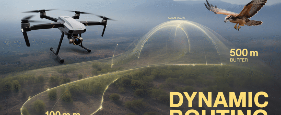
Safe BVLOS operations require more than static altitude limits—they must dynamically adapt to biological hazard data. Most species show minimal disturbance above ~50 m AGL, and a baseline horizontal standoff of ≥100 m aligns with USFWS guidance, but raptors and seasonal nesting zones require stricter exclusion. Territorial species may harass or attack drones, especially when vertical approach vectors resemble predatory dives; thus, routing must prioritize constant-altitude, lateral corridors.
Risk assessment is currently limited by the lack of UAS strike data in FAA wildlife records. Operators must compensate by integrating layered hazard systems—BAM (seasonal), SOAR (predictive), NEXRAD (real-time)—into UTM platforms to generate dynamic no-fly corridors, optimize routing, and reduce energetic stress on migrants. Tactical LiDAR offers only ~30 m detection, underscoring that strategic avoidance—not last-second maneuvering—is the primary safety mechanism. Industry-wide behavioral reporting and environmental integration are essential to establish defensible BVLOS safety cases under MBTA/BGEPA constraints.
I. Executive Summary: Risk Quantification and BVLOS Strategy
The successful, scalable deployment of Beyond Visual Line of Sight (BVLOS) Unmanned Aerial Systems (UAS) operations requires a sophisticated framework for mitigating conflict with avian populations. Current practices must evolve from static flight restrictions to dynamic airspace management based on quantifiable biological hazard data. This report establishes the ecological and regulatory parameters necessary to ensure operational safety and compliance with federal wildlife protection mandates.
The analysis confirms three primary imperatives for BVLOS safety case development. First, quantifiable operational thresholds indicate that flights maintained above 50 meters (164 feet) significantly reduce disturbance effects on most nesting birds, establishing a critical vertical safety margin, supported by a general regulatory baseline of a 100-meter horizontal standoff distance from wildlife.1
Second, the existing risk assessment infrastructure is critically challenged by a systemic lack of data. While the Federal Aviation Administration (FAA) National Wildlife Strike Database identifies high-risk avian groups (waterfowl, gulls, and raptors) based on manned aircraft collisions, it fundamentally lacks specific, quantified data on UAS-related strikes or near-misses.3 This data gap represents a major unquantified safety risk for BVLOS proliferation.
Third, the path to safe expansion necessitates the adoption of real-time and predictive avian hazard systems. Robust BVLOS operations must integrate layered data sources—including Next Generation Radar (NEXRAD), the Bird Avoidance Model (BAM), and soaring condition predictions (SOAR)—into Unmanned Traffic Management (UTM) platforms. This integration enables the implementation of dynamic geofencing, optimal routing, and the enforcement of “no-fly corridors,” ensuring strict adherence to environmental laws protecting migratory and endangered species.5
II. Avian-UAS Interaction Ecology: Behavioral Dynamics and Stressors
The behavioral responses of birds to UAS presence are not monolithic but are context-dependent, driven by species type, life history traits, and perceived threat signature. Understanding these ecological dynamics is essential for designing flight protocols that minimize both physical collision risk and harmful physiological stress.
2.1. Species-Specific Response Profiles: Raptors, Waterfowl, and Migrants
Avian species react to UAS based on an interpretation of the drone as either a novel nuisance or an aerial predator. Large, territorial birds, such as raptors (e.g., eagles) and members of the Corvidae family (e.g., ravens), frequently exhibit aggressive territorial defense mechanisms.7 This behavior manifests as harassment, mobbing, or direct physical attacks on the drone while in mid-flight.9 Documented incidents include a raven attacking a delivery drone in Australia, illustrating the severity of the threat posed by highly defensive birds.9 This aggressive response is significantly heightened during the breeding season when birds are actively defending nests and young.7
In contrast, non-territorial species, particularly waterfowl and ground-displaying birds, typically exhibit avoidance or “fleeing” responses. Lekking prairie chickens (Tympanuchus cupido) demonstrate heightened sensitivity to drone overflight, a reaction often attributed to the vulnerability of displaying birds to attacks by aerial predators like hawks.9 Similarly, studies observing shorebirds, such as the Whimbrel (Numenius phaeopus), reported strong fleeing responses even when recreational drones hovered at altitudes of 20 meters.9
For large-bodied migratory species, such as the Golden Eagle (Aquila chrysaetos), the primary concern extends beyond immediate collision or disturbance to the cumulative energetic costs of forced evasive action. Soaring migrant birds undertake endurance flights and rely heavily on specific mechanisms, such as thermal and orographic lift, to minimize energetic expenditures.10 If a UAS forces a golden eagle, or any large migrant, to deviate from an optimized flight path or execute evasive maneuvers, it imposes a direct and measurable energetic tax. This expenditure affects the bird’s overall condition, fitness, and reproductive success upon completion of migration, having long-term demographical consequences.10 Consequently, mitigation strategies must account for these subtle, yet critical, costs.
A critical analytical finding is that the transition from avoidance behavior (fleeing) to aggression (mobbing/attack) is profoundly contextual. Fleeing is a default strategy employed by general wildlife to avoid a perceived threat.9 Aggression, however, is a high-cost strategy reserved for territorial defense or parental protection.8 This distinction dictates that the highest risk of intentional collision is geographically fixed during seasonal nesting and breeding periods. Therefore, mitigation protocols must be designed to be seasonally dynamic, implementing general avoidance routing during migratory transit and imposing strict physical exclusion protocols (hard geofences) around identified critical habitat areas during peak life history functions.2
2.2. The Role of Visual and Kinematic Signatures (Predator Mimicry)
The way a drone looks and moves often determines the intensity of the avian response, independent of noise levels. Research indicates that the physical shape and wing profile of certain drones significantly influence reactions, with profiles closely resembling raptors causing the most acute disturbance among wildlife.9
Crucially, the dynamic movements of the UAS, known as kinematic triggers, often elicit stronger reactions than a constant flight path. Disturbance occurs more frequently during dynamic flight segments, particularly banking maneuvers, take-off, or landing phases, especially when these actions occur directly over or near a flock.9 Birds appear to interpret these rapid, sweeping movements as the characteristic swooping or diving attack of a predatory bird.9
A particularly dangerous kinematic trigger is the vertical approach vector. Studies have demonstrated that birds react more severely to drones approaching vertically than horizontally.11 This vertical threat perception is highly relevant for ground-level monitoring and for commercial BVLOS operations that involve dynamic altitude changes, such as the terminal phases of package delivery. The intentional attack on a drone by a territorial raptor, often triggered by this vertical approach, poses a dual risk: structural damage to the drone and the potential catastrophic loss of a federally protected bird. For this reason, BVLOS routing algorithms must prioritize constant altitude flight paths and mandate specific, non-vertical approach vectors (lateral flight only) when operating near identified sensitive habitats to minimize the signature that triggers aggression.
It is important to note that not all visual characteristics appear to be significant triggers. Studies assessing disturbance have demonstrated that variables such as drone color, the speed of approach, and repeated flight exercises had no measurable impact on immediate behavioral responses, especially when compared to the strong influence of trajectory and profile.11
2.3. Acoustic Profile and Novel Disturbance
Drone noise constitutes a novel and increasingly pervasive form of anthropogenic disturbance within avian habitats.12 Unlike traditional, continuous sources of noise, such as highway traffic, drones often introduce transient, high-frequency sound profiles directly into ecologically sensitive environments.
Avian species, which are exquisitely attuned to their acoustic environment, rely on sound for essential life functions, including communication, mate attraction, territory defense, foraging, and predator avoidance.12 The intrusion of drone noise can disrupt these crucial functions, leading to potential negative ecological consequences.12 Furthermore, the true measure of disturbance cannot be limited solely to observed behavioral responses (like fleeing). The disruption can induce sub-lethal physiological effects, such as increased heart rate and hormonal fluctuations, linked to elevated metabolic rates and potential declines in physical condition.13 For protected species, such physiological stress can precipitate severe outcomes, including nest abandonment, which constitutes a legal violation of the Bald and Golden Eagle Protection Act (BGEPA).7 Therefore, successful BVLOS operational metrics must strictly adhere to scientifically derived standoff distances that are sufficient to minimize this unseen physiological stress.
III. Defining Quantifiable Operational Thresholds
Safe BVLOS operations require the translation of ecological observations into rigid, measurable flight parameters for inclusion in safety management systems and regulatory compliance documentation.
3.1. Altitude Thresholds for Disturbance Mitigation
Altitude is the most critical and controllable variable for mitigating disturbance effects on avian populations, particularly during nesting periods. A meta-analysis of studies focusing on nesting birds demonstrated a clear safety margin at higher altitudes. Drone flights maintained at altitudes greater than 50 meters (approximately 164 feet) showed no robust evidence of disturbance on nesting birds overall.1
Conversely, flights conducted at lower altitudes, specifically $\leq 50 \text{m}$, showed significantly stronger evidence of disturbance effects. The groups most affected by low-altitude flight included ground solitary nesters and non-ground solitary nesters.1 This finding underscores that the use of drones can be a safe and efficient means of surveying wildlife if altitude and species-specific nesting traits are systematically considered in operational protocols.1
However, the magnitude of disturbance is highly variable by species. Highly sensitive species, such as the Common Redshank (Tringa totanus) and the Osprey (Pandion haliaetus), have shown significantly exacerbated disturbance behavior in response to drone flights.13 In contrast, other species, including the Siberian Crane (Leucogeranus leucogeranus) and the Western Grebe, demonstrated low or negligible behavioral response regardless of altitude.13
This variability presents a challenge to relying on a single, static $50 \text{m}$ altitude limit for all operations. Given that legal frameworks, such as the Migratory Bird Treaty Act (MBTA) and BGEPA, mandate the prevention of harassment for all protected species 7, safe BVLOS protocols must be geospatially dynamic and species-contextualized. General USFWS guidelines recommend an established baseline standoff distance: launching and operating the UAS more than 100 meters (328 feet) horizontally from wildlife.2
3.2. Acoustic and Noise Mitigation Thresholds
For sustained UAS infrastructure, such as delivery hubs or charging stations, acoustic thresholds govern placement to prevent chronic disturbance. The establishment of standoff distances from noise-sensitive areas is critical, and these are often derived from the Day-Night Average Sound Level (DNL) 50dB threshold.8 For example, a high-volume drone hub (100 Average Annual Daily flights) operating within controlled airspace has been proposed to utilize a minimum standoff distance of 360 feet from noise-sensitive areas to maintain acceptable acoustic levels.8 This focus on DNL confirms that long-term habitat placement and noise mitigation requirements must be factored into BVLOS network design, especially near wildlife refuges or critical breeding grounds.12
3.3. Avian Behavioral Response Thresholds for UAS Operation
The following table synthesizes the empirical findings into an actionable reference for BVLOS risk assessment matrices, outlining the conditions that trigger avoidance versus aggression.
Avian Behavioral Response Thresholds for UAS Operation
| Avian Stimulus Parameter | Species Sensitivity/Group | Primary Behavioral Response | Quantified Threshold/Condition | Regulatory/Operational Standard | Supporting Data |
| Altitude (Vertical) | Nesting Birds (General) | Strong Disturbance/Fleeing | Flights $\leq 50 \text{m}$ above nest | Mandatory Avoidance Altitude | [1, 13] |
| Distance (Horizontal) | General Wildlife | Avoidance/Stress Mitigation | Operate $> 100 \text{m}$ (328 ft) from wildlife | USFWS Minimum Standoff | 2 |
| Visual Signature | Waterfowl/Prairie Chickens | High Disturbance/Fleeing | Drone profile resembling a raptor | Design consideration; non-raptor profiles preferred | 9 |
| Kinematic Maneuver | Territorial Species/General | Aggression/Harassment | Take-off, landing, or banking maneuvers over flocks | Route planning to avoid overflight | 9 |
| Approach Trajectory | Raptors/Nesting Species | Aggression/Attack Trigger | Approaching birds vertically | Mandate lateral or tangential approach only | [8, 11] |
| Acoustic Noise (Hubs) | Noise-Sensitive Areas | Chronic Stress/Habitat Abandonment | DNL exceeding 50dB | Minimum 360 ft (100 AAD) operational standoff | 8 |
IV. Analysis of Bird-Drone Collision Risk Data (FAA & USFWS)
A comprehensive assessment of the collision risk environment necessitates a review of existing aviation safety data, primarily derived from manned aircraft operations, and a critical identification of the data deficiencies concerning UAS.
4.1. FAA National Wildlife Strike Database Baseline
Wildlife strikes are a pervasive safety and economic problem within civil aviation, accounting for over $900$ million dollars in damage annually to U.S. civil and military aircraft.4 Between 1990 and 2013, the FAA recorded 142,675 wildlife strikes, with birds involved in 97 percent of these incidents.4
This historical data provides crucial context by identifying the high-risk biological elements in the shared airspace. Three types of birds collectively account for 75 percent of all reported bird strikes: waterfowl (31 percent), gulls (26 percent), and raptors (18 percent).4 These groups are characterized by high kinetic mass and frequent utilization of low-to-mid altitudes. Importantly, the majority of collisions occur at low altitudes during take-off and landing.4 This collision volume directly overlaps with the primary operational airspace utilized by most commercial UAS (0 to 400 feet Above Ground Level). Therefore, the data, while specific to manned aircraft, functions as an essential proxy for mapping the locations and identities of the most common high-risk biological hazards that BVLOS operators must avoid.
4.2. Critical Data Gaps in UAS Collision Reporting
Despite the increasing proliferation of UAS and the recognized risk of shared airspace, a substantial regulatory impediment exists in the form of a critical data gap. The FAA National Wildlife Strike Database, compiled through an interagency agreement with the U.S. Department of Agriculture (USDA), Wildlife Services, focuses exclusively on documenting wildlife strikes to manned civil aviation.14
An explicit analysis of the report confirms that information regarding drone strike data is unavailable, and there is no mention of “drone” or “unmanned aircraft” strike data within the existing framework.3
While there is a lack of formalized statistics, there have been confirmed cases of direct in-flight contact between drones and civil or military manned aircraft worldwide.15 Furthermore, pilot reports of suspected drones in proximity to manned aircraft are increasing, underscoring the growing conflict risk in the shared operational volume.15
The absence of standardized UAS strike data presents a fundamental barrier to regulatory advancement. It prevents safety regulators and commercial operators from accurately modeling the kinetic energy transfer, structural failure probability, and true collision risk profile inherent in large-scale BVLOS expansion. This directly undermines the ability to secure BVLOS waivers that require the demonstration of equivalent safety levels. Furthermore, since the FAA and USFWS are mandated to protect species under laws like BGEPA and MBTA 7, the inability to quantify the increase in bird deaths or injuries attributable to UAS prevents regulators from effectively ensuring that conservation mandates are met during BVLOS proliferation. Proactive industry data collection and mandatory incident reporting are thus essential steps for mitigating this regulatory constraint.
4.3. Contextual Data Compilation: Top Avian Groups in Civil Aircraft Strikes
To illustrate the necessary focus areas for BVLOS risk modeling, the primary high-mass and high-flock density species identified in the manned aviation baseline are summarized below.
Top Avian Groups in Civil Aircraft Strikes (1990–2013 Baseline)
| Avian Group | Percentage of Reported Bird Strikes | Primary Risk Factor | Relevant UAS Operational Impact |
| Waterfowl | 31% | High kinetic mass, frequent flocking behavior, low-altitude flight | High risk along migratory routes and routes passing near water bodies, particularly during low-altitude segments. |
| Gulls | 26% | Flocking behavior, presence in urban and coastal environments | Significant risk in port cities, coastal areas, and urban delivery corridors where food sources are prevalent. |
| Raptors | 18% | High kinetic mass, high territoriality, dependence on thermal lift | Risk along mid-altitude BVLOS routes (above 400 ft) which are shared airspace with soaring raptors (e.g., Golden Eagles).10 |
V. Implementation of Avian-Aware Airspace Management (UTM/BVLOS)
The shift toward routine, reliable BVLOS operations requires integrating advanced environmental and movement ecology data into Unmanned Traffic Management (UTM) systems, allowing for strategic avoidance and dynamic routing adjustments.
5.1. Leveraging Predictive and Real-Time Avian Hazard Data
The technological framework for dynamic avian hazard avoidance is proven, modeled extensively by military and civil aviation safety systems, such as the Avian Hazard Advisory System (AHAS) utilized by the U.S. Air Force.5 This system employs a layered data approach:
- NEXRAD Risk (Real-Time): This component utilizes data from 159 Next Generation Radar (NEXRAD) stations across the United States, with updates occurring every 4–10 minutes.5 The system employs sophisticated suppression models to filter out non-biological targets (weather, ground clutter), converting the remaining reflectivity data into raster images. This provides a dynamic, minute-by-minute risk assessment based on the percentage of a flying area exhibiting biological activity, essential for identifying large, active migratory flocks.5
- SOAR Risk (Short-Term Predictive): The SOAR risk component forecasts hazard levels up to 24 hours in advance, updated every 12 hours.5 It integrates the latest weather data (Model Output Statistics and Upper Air Data) with known population dynamics of large soaring birds. This allows BVLOS operators to anticipate periods and locations where raptors, which rely on thermals to minimize energetic costs 10, will be most active and prevalent, facilitating pre-flight risk adjustments.
- Bird Avoidance Model (BAM) (Static/Seasonal): The BAM consists of comprehensive GIS raster grids spanning the continental U.S. and Alaska.5 This model provides a long-term, seasonal risk baseline by calculating the mean bird mass present during specific bi-weekly periods throughout the year. The BAM establishes a foundational layer for strategic corridor planning and defining static exclusion zones where high-mass avian activity is historically common.5
This comprehensive approach is further strengthened by integrating broad ecological datasets. Citizen science repositories, such as the eBird database, contain the world’s largest collection of data on North American birds and are used to refine general migratory flyway categorizations into specific, temporally dynamic species distribution models.6 These models allow UTM systems to transition from generic assumptions about “flyways” to actionable, microscale route planning based on documented migratory connectivity.
5.2. Technical Framework for Dynamic BVLOS Routing
The integration of these diverse data layers demands the adoption of sophisticated UTM processing capable of Probabilistic Risk Modeling. Systems based on frameworks like Probabilistic Mission Design (ProMis) can be adapted to calculate the probability of avian collision ($P_{collision}$) based on bird density (NEXRAD), bird mass (BAM), and predicted altitude/trajectory (SOAR/eBird).18
The result of this probabilistic calculation must be the automatic generation of Temporary Flight Restrictions (TFRs) or dynamic hazard zones (D-Zones) within the UTM. Operational flight plans would then be routed to minimize exposure to these high-risk flight volumes, potentially rerouting a path laterally or vertically to adhere to the $50 \text{m}$ safety altitude and $100 \text{m}$ standoff rules established for disturbance mitigation.1
For tactical, last-second safety, onboard sensor layers provide a necessary reinforcement. LiDAR sensors mounted on drones have demonstrated the capability to detect birds of various sizes, including pigeons, falcons, and seagulls, at approximately 30 meters.20 Detection performance improves as the bird approaches and increases with bird size, but accuracy degrades with increasing drone-bird relative speed.20 The finding that the effective tactical detection range is only 30 meters highlights a critical limitation: this short distance provides minimal reaction time for collision avoidance maneuvers, especially against high-mass, high-speed raptors or waterfowl. This reinforces the principle that the primary safety strategy must be strategic avoidance (via UTM data integration) rather than tactical reaction (via LiDAR), underscoring the necessity of strict adherence to established vertical separation thresholds ($>50 \text{m}$).
5.3. Avian Hazard Prediction and Mitigation Systems Integration
The required technological inputs for a truly avian-aware UTM system are summarized below:
Avian Hazard Prediction and Mitigation Systems Integration
| System Type | Data Input Sources | Temporal Resolution | Application to BVLOS Planning |
| Static Risk Model (BAM) | Historical bird mass distribution, GIS habitat grids, species life cycle data | Seasonal/Bi-weekly (Long-Term) | Strategic corridor planning, defining permanent avoidance areas, and compliance with habitat protection (MBTA/BGEPA). |
| Predictive Model (SOAR) | Meteorological (MOS/UPA), soaring bird population dynamics | 12–24 hours (Medium-Term) | Tactical flight delays, pre-flight altitude optimization, and identification of high-raptor-risk windows. |
| Real-Time Detection (NEXRAD) | Radar reflectivity, biological target removal models | Minutes (Current Risk) | Dynamic in-flight rerouting, generation of immediate Temporary Flight Restrictions (TFRs) for large flocks. |
| Tactical Avoidance (LiDAR/Radar) | Onboard sensor returns, object classification algorithms | Instantaneous (Near-Field) | Last-second collision avoidance, reinforcing strategic separation adherence. |
The technological challenge for civilian BVLOS is now defined by data accessibility. The AHAS model and NEXRAD processing are proven, but civilian operations require these historically military/manned aviation datasets to be standardized and delivered via API endpoints for real-time integration into commercial flight planning and UTM platforms.5
VI. Regulatory Compliance and Strategic Recommendations
The expansion of BVLOS operations is inseparable from the strict regulatory obligations governing the protection of wildlife. Compliance strategies must be robust, transparent, and enforceable to gain regulatory approval.
6.1. Legal Imperatives for Wildlife Protection
Federal law provides stringent protection for avian species, notably through the Migratory Bird Treaty Act (MBTA) and the Bald and Golden Eagle Protection Act (BGEPA).7 These acts protect not only the birds themselves but also their feathers, parts, nests, nest trees, and roosts.7
The defining legal constraint for UAS operation is the prohibition of harassment, pursuit, or intentional disturbance of animals during critical life history functions, such as breeding, nesting, and rearing of young.2 Drone operations that cause breeding pairs, particularly protected species like eagles, to abandon nests for the season constitute an actionable offense that can result in substantial fines and legal penalties.7 This underscores the necessity of adhering to established operational requirements, including designated takeoff/landing areas, defined altitude restrictions, and strict adherence to geofenced no-fly zones over sensitive habitats.2
6.2. Strategic Recommendations for BVLOS Protocol Development
To bridge the gap between technological capability and regulatory compliance, the following strategic recommendations must be adopted:
- Mandatory Avian Hazard Data Integration: All BVLOS safety cases and subsequent operational protocols should mandate the utilization of predictive and real-time avian hazard components (NEXRAD, SOAR, and BAM data) to dynamically calculate and mitigate avian collision and disturbance risk throughout the flight lifecycle.
- Implementation of a Tiered Standoff Protocol: A hierarchical system should be adopted to manage variable species sensitivity and spatial risk:
- Tier 1 (General Wildlife): Minimum 100 meters horizontal standoff distance.2
- Tier 2 (Nesting/Vulnerable Species): Minimum 50 meters vertical altitude clearance 1, coupled with automated, zero-tolerance geofencing (no-fly zones) around known critical habitat areas identified through USFWS consultation and ecological mapping.22
- Tier 3 (Kinematic Mitigation): Mandate constant altitude flight profiles and prohibit vertical approach vectors near identified sensitive habitats to minimize the predatory kinematic signature.11
- Mandatory Incident Reporting Mechanism: To address the critical data deficit, the FAA, in partnership with the USFWS, must mandate the standardized reporting of all UAS-related bird strike incidents and near-misses. This data, including species identification and detailed operational parameters, must be integrated into an expanded FAA 5200-7 framework. Furthermore, operators must be required to note any observed changes in wildlife behavior or impacts to resources during post-flight communication procedures.22
VII. Conclusion: Advancing Risk Tolerance through Data-Driven Management
The safe and regulated expansion of commercial BVLOS operations is fundamentally contingent upon the industry’s capacity to demonstrate superior environmental stewardship. This requires moving beyond simplistic static rules to embrace complex, dynamic airspace management systems.
The available scientific evidence clearly defines the thresholds for avoiding ecological disturbance ($>50 \text{m}$ vertical clearance, $>100 \text{m}$ horizontal standoff) and identifies the kinetic triggers for avian aggression (vertical approach, raptor-like profiles). However, the lack of UAS-specific strike data presents a regulatory hurdle that can only be overcome through mandatory, transparent incident reporting.
By proactively integrating robust environmental intelligence—such as NEXRAD reflectivity and eBird-derived migration models—into UTM systems, the UAS industry can generate highly defensible dynamic “no-fly corridors” and optimize flight routes. This strategy effectively addresses both kinetic collision risk (avoiding high-mass waterfowl and raptors) and ecological disturbance risk (adhering to behavioral thresholds), transforming the currently unquantifiable hazard of bird-drone interaction into a managed, compliant, and predictable operational risk. This data-driven approach is the requisite foundation for securing regulatory acceptance of routine BVLOS flight.
Works cited
- A meta-analysis of disturbance caused by drones on nesting birds, accessed November 5, 2025, https://journal.afonet.org/vol94/iss2/art3/
- Tips for Responsible Drone Use | U.S. Fish & Wildlife Service, accessed November 5, 2025, https://www.fws.gov/refuge/oregon-islands/tips-responsible-drone-use
- Wildlife Strikes to Civil Aircraft in the United States, 1990–2022 …, accessed November 5, 2025, https://www.faa.gov/sites/faa.gov/files/Wildlife-Strike-Report-1990-2022.pdf
- Threats to Birds: Collisions-Aircraft | U.S. Fish & Wildlife Service, accessed November 5, 2025, https://www.fws.gov/story/threats-birds-collisions-aircraft
- About the Avian Hazard Advisory System (AHAS), accessed November 5, 2025, https://www.usahas.com/about.html
- Integrating data types to estimate spatial patterns of avian migration across the Western Hemisphere – PubMed Central, accessed November 5, 2025, https://pmc.ncbi.nlm.nih.gov/articles/PMC9787853/
- Keeping wildlife safe from drones | U.S. Fish & Wildlife Service, accessed November 5, 2025, https://www.fws.gov/story/keeping-wildlife-safe-drones
- Draft Environmental Assessment for DroneUp, LLC Proposed Drone Package Delivery Operations in Dallas–Fort Worth, Texas – Federal Aviation Administration, accessed November 5, 2025, https://www.faa.gov/uas/advanced_operations/nepa_and_drones/DroneUp_EA_Final.pdf
- Impact of Drone Disturbances on Wildlife: A Review – MDPI, accessed November 5, 2025, https://www.mdpi.com/2504-446X/9/4/311
- Flight responses by a migratory soaring raptor to changing meteorological conditions – PMC, accessed November 5, 2025, https://pmc.ncbi.nlm.nih.gov/articles/PMC3440984/
- Approaching birds with drones: first experiments and ethical guidelines – PMC – NIH, accessed November 5, 2025, https://pmc.ncbi.nlm.nih.gov/articles/PMC4360097/
- Drone Noise Impact on Protected Bird Species → Scenario – Prism → Sustainability Directory, accessed November 5, 2025, https://prism.sustainability-directory.com/scenario/drone-noise-impact-on-protected-bird-species/
- A meta-analysis of disturbance caused by drones on nesting birds – Journal of Field Ornithology, accessed November 5, 2025, https://journal.afonet.org/vol94/iss2/art3/JFO-2023-259.pdf
- Wildlife Strikes to Civil Aircraft in the United States, 1990 – 2024 – Federal Aviation Administration, accessed November 5, 2025, https://www.faa.gov/airports/airport_safety/wildlife/wildlife-strike-report-1990-2024
- Drone Safety Risk: An assessment – Civil Aviation Authority, accessed November 5, 2025, https://www.caa.co.uk/publication/download/16315
- Macroecological Analysis of Bird Migration Routes in North America Using eBird Data: Beta Diversity Perspective – MDPI, accessed November 5, 2025, https://www.mdpi.com/1424-2818/17/8/529
- Integrating data types to estimate spatial patterns of avian migration across the Western Hemisphere – USGS.gov, accessed November 5, 2025, https://www.usgs.gov/publications/integrating-data-types-estimate-spatial-patterns-avian-migration-across-western
- Hybrid Many-Objective Optimization in Probabilistic Mission Design for Compliant and Effective UAV Routing – arXiv, accessed November 5, 2025, https://arxiv.org/html/2412.18514v2
- Hybrid Many-Objective Optimization in Probabilistic Mission Design for Compliant and Effective UAV Routing – arXiv, accessed November 5, 2025, https://arxiv.org/html/2412.18514v1
- Assessment of LiDAR-Based Sensing Technologies in Bird–Drone Collision Scenarios, accessed November 5, 2025, https://www.mdpi.com/2504-446X/9/1/13
- How to Use Drones for Wildlife Conservation? – JOUAV, accessed November 5, 2025, https://www.jouav.com/blog/wildlife-drone.html
- Best Practices – U.S. Fish and Wildlife Service, accessed November 5, 2025, https://www.fws.gov/doiddata/dwh-ar-documents/4722/DWH-ARZ009948.pdf